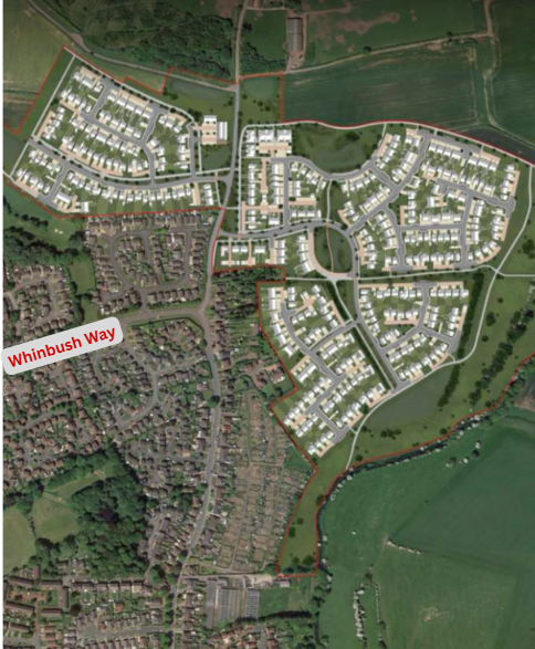
24/00772/FULE - Phase 1 - 450 houses top of Barmpton Lane/Whinbush Way
What is this for?
Development of 450 houses plus pub and shop at the top of Barmpton Lane.
Objection Points
• Section 123 of the Local Government Act 1972: The land at Muscar House Farm in the Whinfield area that forms part of this planning application is still Council owned and must comply with Section 123 of the Local Government Act 1972 whereby the local authority must advertise the intended disposal in a local newspaper in two consecutive weeks and consider any objections that are made before taking a decision to proceed. Section 123 has been used previously on this land in 2014. Can the Council confirm it will follow Section 123 and not the supplementary Section 111 of the same Act?
• Darlington Northern Link Road: The Tees Valley Combined Authority is currently undertaking development work for the Darlington Northern Link Road (DNLR) and will then produce an Options Assessment Report (OAR) in accordance with Department for Transport guidance. The report will need to assess route options, including the previously identified preferred option, to inform a recommendation on which route alignment should be taken forward. They are considering a wide range of options including Skerningham Garden Village in the assessment, confirmed by Tom Bryant, TVCA’s then Head of Transport. The Tees Valley Mayor stated it would be between Route A (the previously identified preferred option) and Route B which goes through Skerningham and he posted a map, which was also shared by the Whinfield councillors on social media. More recently, in September 2025, he stated on a live phone-in that the DNLR would be going through Skerningham. This would be a major change to the Local Plan, Design Code and Masterplan with zero public consultation. This planning application should not go before the planning committee until the preferred route option is identified and Skerningham has officially been ruled in or out.
• DNLR: The Masterplan is not consistent with Local Plan Policy H10 nor the Design Code because it makes reference to the DNLR (although they call it the DNRR - Darlington Northern Relief Road).
• Traffic: NPPF 116 says that development should only be prevented or refused on highways grounds if there would be an unacceptable impact on highway safety, or the residual cumulative impacts on the road network would be severe. The bid to join the Garden Communities programme also stated that the scheme would complement the existing surrounding communities and would not place a burden on existing services and infrastructure. Allowing 449 dwellings to be occupied with only one entrance will negatively impact the existing local roads by making them busier, increasing pollution and compromising pedestrian safety, particularly down Barmpton Lane as it heads towards the A1150.
• Traffic modelling: Darlington Borough Council’s traffic modelling for the Skerningham allocation when preparing the Local Plan was working on the basis of the entire distributor road being in by 2030. The modelling also showed that the eastern link would be in by the time 90 dwellings were built off Barmpton Lane (YouTube video available to back up this claim), yet this planning application is for 450 dwellings and no road over to Bishopton Lane whatsoever, but apparently the Council now agrees that 450 dwellings can be accommodated before the eastern link is required! Page 41 of the Design Code recognises that the existing southern highway (so Whinfield Road/A1150) is already at close to capacity. The capacity issue on this road is being used to build a case for funding for a Darlington Northern Link Road. How therefore can Chapter D - Transport claim that the likely effect of the Phase 1 development with regard to severance, driver delay, pedestrian (and non-motorised user) delay, non-motorised user amenity, fear and intimidation, and road safety will be negligible and not significant? Point 116 of the NPPF says, “Development should only be prevented or refused on highways grounds if there would be an unacceptable impact on highway safety, or the residual cumulative impacts on the road network would be severe.” The impact on the road network will be severe because all traffic off this development will filter down to the A1150 via Barmpton Lane or Whinbush Way. Barmpton Lane is a undulating, winding road with parked cars on the highway and is not suitable for this volume of extra traffic. There would also be queuing traffic on Whinbush Way as traffic waits at the traffic lights to join Whinfield Road. This development should be refused.
• Distributor road: The Local Plan is clear that prior to the occupation of between the 200th and 450th dwelling on the eastern part of the allocation the section of the local distributor road between Barmpton Lane and Bishopton Lane shall be delivered but this planning application does not propose even starting to put this road in during Phase 1, let alone finish it. This goes against Local Plan policy contained within the blue boxes which carry most weight, according to Council officers. Its construction needs to start during Phase 1 to be in place by the occupation of between the 200th and 450th dwelling. If it was meant to be in place by the occupation of the 450th dwelling and not before, the Local Plan wording wouldn’t have included a range and instead would say “by” the occupation of the 450th dwelling. The Masterplan shows this section of road finally being built, plus a further 150 houses at Skerningham Lane East, in just two years, Phase 2 between 2031-2033. This would mean the 450th house built during Phase 1 and none of the further 150 houses in Phase 2 being able to be occupied until the road is completed. It would also mean all traffic from 449 occupied homes from Phase 1 plus construction traffic for the further 150 houses at Skerningham Lane East to be built during Phase 2 still using Barmpton Lane only to gain access. This is totally unacceptable.
• 300 dwellings maximum with only one entrance: Banks’ pre-application guidance says that the maximum number of dwellings served should not exceed 300 units off a single access point and if more than 300 are proposed, a second access must be secured. How therefore can 450 houses with only one access point off Barmpton Lane be acceptable? Barmpton Lane already serves existing properties at Low Skerningham, Elly Hill and Barmpton Village.
• Access: Point 117(d) NPPF is clear, applications for development should allow for the efficient delivery of goods, and access by service and emergency vehicles. This is not possible with only one way in and out for 450 new builds and existing properties at Low Skerningham (9), Elly Hill (3) and Barmpton (18) should the single access road be blocked by an accident. There are working farms in the area and a livery yard so large vehicles pass through the site. In summer the area can be a hotspot for anti-social behaviour and the fire brigade has been called out to several fires in recent years. Safe and suitable access to the site cannot be achieved for all users (NPPF 115b) should Barmpton Lane, the one way in and out, be blocked.
• Education: The Masterplan states that the Council’s assumed pupil yields are 20 primary aged children and 12 secondary school aged children per 100 dwellings and that a development of up to 3,700 dwellings overall equates to a need for 740 primary school places and 444 secondary school places. That within the current plan period, 1,450 dwellings are projected to be delivered in the period to 2036. This equates to a need for 290 primary school places and 174 secondary school places. Using this methodology, a development of 450 dwellings would require 90 primary school places and 54 secondary and not the totals submitted against this planning application by Darlington Borough Council’s Education Department which deducts 90 affordable homes from the 450 total to come up with figures only relating to need generated from market housing dwellings. This drags the totals down from 90 to 72 for primary and 54 to 43 for secondary. These figures are maybe being used to work out what education contributions will be needed and affordable housing elements of a scheme are not included in this but you would still expect to see figures that show the total pupil yield for primary and secondary from 450 homes, this would be 90 and 54, and if there is sufficient capacity. Is there?
• Schools: With no spare capacity at Haughton Academy for secondary pupils currently, according to the Education Department’s submission, where does this leave the claims in the Masterplan that the education need associated with the delivery of Phases 1, 2 and 3 of the development (up to 2036) will be met by existing schools? There are other developments proposed within the catchment area of Longfield School which will affect capacity there. The capacity at St Bede’s Catholic Primary was considered for Banks’ outline planning application on the western portion of the Skerningham allocation but not for this planning application despite the school being within the 3-mile travel to learn threshold. Is there capacity at St Bede’s?
• Nursery places: The prospectus produced for the Garden Village bid and Policy H10 (d) mentions nursery provision. How will this be factored in for this planning application?
• Stressholme: Ken Maddison’s objection on the planning portal against planning application 24/01051/CON is extremely enlightening and is a generic issue that applies to this development too. To summarise, as of 1st January 2024 Stressholme’s remaining capacity was 2,500 dwellings. The connection into Stressholme from Long Newton/Teesside Airport on 1st April 2025 is equivalent to 9,500 dwellings, or, even if you quarter the amount by accounting for some over design and factors of safety calculations, 2,400 dwellings will still be connected. The Council has approved fully a minimum of 1,000 dwellings that have not been started or built yet but which Northumbrian Water Ltd must connect to the network. This year, around 400-500 dwellings have been built and will be connected.
• Flooding: Flooding risk will increase elsewhere if this planning application is approved, NPPF point 181. Houses downstream backing on to the floodplains around Rivergarth estate, Great Burdon and Haughton Grange estate are already seeing flood water up to their garden fences. Haughton Road around its junction with McMullen Road also floods, causing traffic problems. The golf course, with its underground lake from which the club draws water, already floods during wet spells, shutting the course down. Concreting over nearby fields will only exacerbate this problem. The idea that a western area of the development may discharge to a drain within Darlington Golf Club is a concern raised by the Lead Local Flood Authority because the watercourse is culverted beneath the existing residential estate and the additional surface water flow represents significant additional flood risk off-site to existing properties. In November 2023, sandbags had to be used to protect properties in Whinfield that back on to the drainage ditch. Furthermore, if Bellway Homes had received planning permission for Elm Tree Farm, they had permission to discharge water to that same watercourse, with a recommendation made for the Council to take out suitable indemnity insurance to cover themselves for flood claims from existing residential properties. There is clearly a problem already.
• Stand-off zones: The landfill site does not appear to have been well maintained over the years, with several vent stacks missing their lids and a hissing sound being audible from some after prolonged rainfall. There is also still an eggy odour emanating from parts of it. The following is printed in a Skerningham Estates Ltd document submitted during the Local Plan examination, “The development should incorporate a stand-off area to the former Barmpton Quarry landfill site which is the main source of potential contamination in the site.” There needs to be a stand-off zone of 250m from the landfill to protect new residents from gas migration. NPPF 197 says, “Where a site is affected by contamination or land stability issues, responsibility for securing a safe development rests with the developer and/or landowner.” What site investigations, if any, have been done? There is also a livestock shed which needs to be 400m from the curtilage of any new dwellings. The shed produces smells and attracts flies and rats.
• Design Code Movement: “Yes” has been ticked in the Design Code checklist for the question “Are peoples daily needs met within a walkable (10 minutes there and 10 minutes back) radius of their home? (food, healthcare, education, leisure, bus stops)” however the applicant is relying on their bus strategy to enable people to reach the doctors surgery, dentist and schools because it is not possible to reach any of these services on foot in 10 minutes. This is not how a 20-minute neighbourhood should be measured. Taking 162 Barmpton Lane which is close to the edge of the planning application site as a starting point for measuring walking distance, Whinfield Medical Practice is a 11 minute walk, the nearest dentists on Stockton Road 16 minutes, Whinfield Primary 11 minutes. The Design Code is clear that the Garden Village should have a compact 20 minute (10 minutes there and 10 minutes back) “walkable” neighbourhood design philosophy in order to encourage walking and cycling for all local trips by all ages. The Masterplan acknowledges this isn’t possible. This will be a car-dependent development. “No” should be ticked. The scheme does not meet criteria requirements and cannot be passed.
• Graves: The Masterplan acknowledges there are human graves in the woods and says they will continue to be respected, however, as has been discussed previously in Council meetings, the locations of the graves are unknown because no burial register was kept for the site. Shocking. With suggestions made of putting trim trail equipment etc in the woods, no changes to the woods should be made until the grave locations are known in case memorial trees for example are accidentally removed. Knowing the position of one person’s grave there, which is well known because of the publicity given to their funeral, does not mean that’s where all of the people are buried and it is extremely risky to just assume. The people laid to rest can only truly be respected if there is awareness of where they are.
• Skunny Woods: The Northern Parcel should include the older woods towards the East Coast Mainline known locally as Skunny Woods. This woods is a Priority Habitat Deciduous Woodland the same as Hutton Plantation, which is included. As a side note, why was Skunny Woods not included for any bat survey work? It appears it wasn’t touched by remote monitoring nor transect surveys which seems strange for a wood with lots of veteran trees. The entire woods is a large nature reserve according to the Council website. It was listed as a Site of Nature Conservation Importance (SNCI) in the 2015 SHLAA and the Council website states SNCIs are protected against destruction. In the list of Constraints for this planning application, Skerningham Plantation is down as a Local Wildlife Site in one entry. The Masterplan shows the road will go through Skunny Woods, with the developer noting against public comments made during the Masterplan consultation that it has not been possible to find an appropriate option which avoids the woodland, however the Skerningham Railway Crossing - Feasibility Study 30/09/22 shows four options, with the road crossing the mainline from the west and making a 90-degree turn to run parallel to the mainline and avoiding the woods. Therefore Skunny Woods can be avoided and can be included in the Northern Parcel.
• Green buffer: The Design Code says a green buffer should be provided between the existing and new development in character area Skerningham Lane East. The gardens of the new properties are long and join on to existing properties on Galloway estate however this is not a green buffer because gardens can be paved over, Astro-turfed and become pretty sterile environments. Although they are proposing planting small-medium native trees where the gardens meet, will these trees be protected using TPOs? If not, what is stopping them from being removed by the home-owner? The Council’s Tree and Woodland Strategy 2021-2031 says the Council will make Tree Preservation Orders and/or attach appropriate conditions to planning permissions to safeguard existing trees and ensure that new planting is established and protected. Can this be confirmed this will happen? What is needed here is a true green buffer that wildlife can pass along with ease, use as foraging habitat etc. The vulnerable-to-extinction hedgehogs would benefit from this, for example, and the local foxes that use it presently. So a buffer that encourages wildlife but discourages humans from passing through.
• Hedgerows and veteran/ancient trees: Currently, long, old hedgerows flank either side of Barmpton Lane. There is no need to grub out both of these hedgerows to widen the road. NPPF 136 says existing trees should be retained wherever possible and it is possible. The road could be widened by shifting it off into the Barmpton Lane character area which would allow the hedgerow on Galloway estate side of the road to be retained in the most part and some character of the lane to remain. It meets the criteria for protected hedgerows as set down by the Government in terms of length, location and importance. The road entrance into Skerningham Lane East character area should be designed around the two trees in this line of hedgerow both of which provide hollows for bats to use and the ash is a nest site for a pair of stock doves. The field maple, which is earmarked to be felled, was measured by the ecologist Skerningham Woodland Action Group hired and was noted as being “beyond truly ancient” and is the second largest in County Durham. The applicant’s ecology report does not record any ancient trees and states that trees range in age from immature to mature and veteran. This is wrong. There are two old stone gateposts in this hedgerow which must be kept and incorporated somehow. This hedgerow connects nicely into the green buffer the Design Code says is needed between the Galloway estate and new houses but which isn’t provided yet. By creating a grassy buffer there and by retaining a large portion of this hedgerow, plus trees, this would connect up habitats and create an ecological corridor which wildlife needs and deserves. The hedgerow offers suitable nesting opportunities for birds and a home for hedgehogs and the common toad, a species which migrates through the site in spring up to ponds on the landfill for example. The hedgehog and common toad are UK BAP Priority Herptile Species (2007). Local Plan Policy ENV 7 says development will avoid or mitigate adverse impacts upon BAP priority or protected species.
• Tree and Woodland Strategy 2021-2031: The Council’s Tree and Woodland Strategy 2021-2031 says the Council will plant a minimum of two trees for every tree that is removed and where appropriate trees that are lost as part of any new development will be replaced within 5 years by the developer. That where a significant tree is removed for a legitimate reason, the replacement will be specified as a heavy standard. A condition should be put in to treat all of the 11 trees they are wanting to remove as significant so that they are replaced with a heavy standard and TPOs placed on them. Also, the 800m of hedgerow they plan to grub out must be replaced by new hedgerows totalling 1600m in length, so double what they want to remove. If the Council plants a minimum of two trees for every tree lost, the same ratio should be applied to hedgerows lost because they too are ecologically valuable and great at sequestering carbon.
• Design Code Nature: “Yes” has been ticked in the Design Code checklist for the criteria “Does the design interconnect existing ecological resources such as woodlands, watercourses, hedgerows, fence lines and wet areas so as to create a green network which allows easy wildlife movement throughout the site?” The answer should be no when they are proposing removing 800m of hedgerow from the southern parcel which act as wildlife corridors. They claim that given the extent of hedgerows within the wider countryside, the loss of 800m of hedgerow is considered to be of no more than small magnitude as the areas to be lost are species poor and the significance of effect is considered to be minor adverse and therefore not significant. Is there evidence to show the extent of hedgerow provision in the wider countryside to back up this claim? How does a hedgerow somewhere in the wider countryside help a hedgehog that uses some of the 800m of lost hedgerows in Phase 1? It’s amazing how developers laud the planting of new hedges and whips as if they are saving the planet but if established hedgerows or trees are an obstacle in their path, suddenly they become not important or the health-and-safety card is played to deem an older tree unsafe.
• BAP Priority and protected species: There are many red and amber-listed birds, Schedule 1 species and BAP Priority Species that use and need the fields in the southern parcel and many more that are found within 3km of the site. Just because there is similar habitat beyond Phase 1, this doesn’t mean it can absorb the influx of species that will be displaced. If they are capable of escaping the bulldozers that is! If Local Plan Policy ENV 7 says development will avoid or mitigate adverse impacts upon BAP Priority or protected species, what is proposed for the impact on the following species which have been seen on the Southern Parcel and/or within less than 3km:
- SCHEDULE 1 SPECIES: Fieldfare, Black-tailed godwit, Harriers (all species), Kingfisher, Red kite, Barn owl, Peregrine, Redwing, Swan whooper, Wood sandpiper.
- UK BAP PRIORITY BIRD SPECIES (2007): Skylark, Lesser redpoll, Common linnet, Common cuckoo, Yellowhammer, Reed bunting, Herring gull, Black-tailed godwit, Common grasshopper warbler, Yellow wagtail, Spotted flycatcher, House sparrow, Eurasian tree sparrow, Grey partridge, Willow tit, Common bullfinch, Common starling, Song thrush, Ring ouzel, Northern lapwing.
- UK BAP PRIORITY TERRESTRIAL MAMMAL SPECIES (2007): West European hedgehog, Brown hare.
- UK BAP PRIORITY HERPTILE SPECIES (2007): Common toad, Great crested newt.
- UK BAP PRIORITY TERRESTRIAL INVERTEBRATE SPECIES (2007): Dingy skipper, Wall, White-letter hairstreak, Blood-vein, Cinnabar.
• Pub: The Garden Village prospectus the developers created in conjunction with the Tees Valley Mayor and Darlington Borough Council says the NHS Healthy New Town Principles would be at the heart of the design, for example providing access to affordable, healthy foods and creating buildings that support and facilitate good health. The proposed pub is a bad idea for health. It would also create noise and possible anti-social behaviour and affect the amenity of Elly Hill. It would also place a burden on pubs in neighbouring wards by competing for their trade. The Garden Village bid says community facilities would be things like a community hub building serving various functions, for example a library, community event space, IT centre etc which would be more suitable.
• Design Code Movement, Buses: “Are 80% or more households within 400 metres walking distance of a bus stop served by a regular day time service (at least every 30 minutes)?” “Yes” has been ticked but this can not be backed up by evidence on the ground. The number 10 bus that serves Whinfield ward might be timetabled to be a regular service however in reality it is anything but. There have been problems with reliability for three years at least. Search the word “Arriva” on the Facebook page Whinfield News which is run by the local councillors and you will see several posts about the poor service. January 2022 some comments to a post include: “Value for money?! You must be laughing!!! The service is an abomination! I pay £45 a month for buses that are cancelled or no shows whether that be 10 ,9 or X66 in to town. The only thing consistent about the service is the constant anxiety and panic about getting to work on time.” And, “Value for money your joking, don’t even bloody turn up Whinfield Service,” followed by several angry-face emojis. August 2022 the councillors posted: “You asked and now we are acting. Many residents have reported to us the utter disarray of bus services affecting our ward at the moment. Enough is enough! People rely on these services to get to work and to live their lives. Something needs to be done and we need Ariva to answer for these issues.” To this day the bus service remains not good enough and if local residents had to tick the Design Code box it wouldn’t be the “Yes” one. With schools, doctors, dentists etc all being more than 10 minutes away on foot and a bus service that is unreliable on top of that, residents will just jump in their cars instead.